Two wonderful things happened during the past few weeks. The first is that Joanne VanCoevern, manager of the Santa Fe Trail Association, shared with me a series of very detailed maps of the Santa Fe Trail. The second is that a fellow writer introduced me to Google Map Engine Lite, which lets you draw your own maps. So, after our recent adventure following the Santa Fe Trail in Douglas County, Kansas, I’m able to show you where the trail runs (roughly) and how we followed it.

My very first Google Map Engine map. The black line is the Santa Fe Trail; the red line is the route we followed. Click on the map to visit the Google Map Engine map.
The black line represents what is officially believed to be the common route of the Santa Fe National Historic Trail. An important thing to remember is that people didn’t really follow the trail like a road. If there was a lot of mud, they veered off the trail onto dryer land. If they thought they could take a short cut, they took a short cut. Today, though, we have to stick to the roads (the red line). The local farmers and ranchers frown upon driving through their fields just to follow the trail.
We started our adventure at Simmons Point Stage Station and followed the trail backwards (people heading to Santa Fe would have moved in a southwesterly direction; we were on the return trip). We’d noticed this building before, but we didn’t realize its historic significance until we were studying the trail map. While it is believed to be a fairly “new” building–Simmons Point wasn’t constructed until the 1880s, after the trail was technically decommissioned because the railroads were in place–it’s still considered an important trail site. The trail itself runs right behind the house. Unfortunately, this building is in terrible disrepair and likely won’t survive much longer. Go see it now while you still can.

Simmons Point Stage Station, which was likely built after the Santa Fe Trail was in heavy use. This historic building is in terrible disrepair and will likely collapse in the near future.
Next, we headed northeast to find the marker at Globe, which was once a mail stop. From the marker, looking southwest, you can actually see the silo and tower next to Simmons Point.

Looking southwest from the marker for Globe, you can see the silo and tower north of Simmons Point Stage Station.
We then zigzagged northeast until we found Willow Springs, which was a major watering hole along the trail. Today, this area is surrounded by beautiful farmland and there is a historic German Baptist Brethren church just south of the historic marker.

Willow Springs, once an important watering stop on the Santa Fe Trail. Today it is also the location of one of the oldest German Baptist Brethren churches in Kansas.
As we headed east, we watched the land for any signs of trail ruts, but most of this area has been heavily cultivated for farming and nothing was obviously visible. We crossed U.S. 59 and headed toward what the trail map called The Narrows: an area where there was only a thin strip of land high enough to keep wagons and beasts of burden out of the mud.
We found a marker for Brooklyn, which was once a trading post on the trail. The post was destroyed by William Quantrill’s raiders in 1863. A weirdly cheerful marker just across the road highlights the area as being on Quantrill’s trail.

Brooklyn, once a stop on the Santa Fe Trail until it was burned down by Quantrill.

The disturbingly cheerful marker for Quantrill’s Trail.
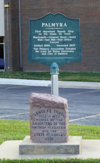
The trail slants to the southeast toward what was once Palmyra, a little town that was quickly incorporated into the larger Baldwin City. Historic Markers near the high school give a brief history of the town. An important well is just a block east of the school.

The old Historic Marker for Palmyra, which has since been incorporated into Baldwin City.

The new Historic Marker for Palmyra.

Palmyra Well, once a major watering stop on the Santa Fe Trail.
Southeast of Baldwin City are some of the most impressive trail ruts along the trail. The camera just doesn’t do justice to what you can actually see on the ground. The satellite images are even more impressive. Because it was already dark when we reached this point, I’m posting a photo I shot in May when we were visiting Black Jack Battlefield, which is just south of the trail ruts.

Santa Fe Trail ruts near Black Jack Battlefield east of Baldwin City. The ruts are deep enough that they’re visible in satellite images.
The Santa Fe Trail Association is a fabulous resource for trail history and location information. There’s something magical about knowing that this important road, which once wandered out into the unknown, now flows through today’s farm fields and backyards.


