Research on the next true crime book is taking me to Crawford County, Kansas, an area whose early history revolved around the coal mining industry. Realizing my husband and I knew next to nothing about coal mining in Kansas, we made a trip to the Miners Hall Museum in Franklin, Kansas to learn some basic mining history.

A nation in the midst of tremendous industrial growth was hungry for coal. This is the real deal, and it’s dirtier and heavier than I had imagined.
This little museum is packed with history, and staff members will help orient you through your visit. My first surprise was in discovering that the coal mining companies owned a substantial portion of land in this area, and they sometimes paid their employees in script to be spent at the company stores. These were company towns. I knew this was common in the Eastern U.S., but I had no idea that Kansas mines operated this way.
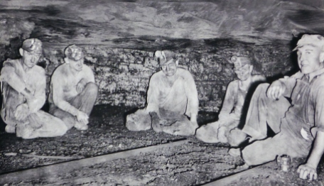
In addition, miners where obligated to provide their own equipment, from their picks to the helmets and carbide lamps on their heads.
Mining was incredibly labor intensive and dangerous work. The museum includes a binder several inches thick of the injuries and deaths documented in the local mines. In addition, Kansas mines were still employing children. In 1921, the women–mothers, wives, daughters, girlfriends–rallied a protest on the mining companies. More than 2,000 women interrupted work in the mines for three days. They were known as the Amazon Army.
Like the mines in Pennsylvania, many of the Southeast Kansas miners were from the Little Balkans. The area still has a rich Slavic and Italian heritage, which is also reflected in the museum and cultural events.
After the museum, we ventured southwest of Pittsburg to West Mineral, Kansas, the home of Big Brutus. It’s really hard to capture the size of this monster with a camera; but if you look closely at these photos, you’ll see tiny little people near Brutus, whose bucket could gather 150 tons of earth in a single scoop. After Brutus was retired in 1974, he became an attraction to help visitors understand the more modern mining process. This giant machine could be operated by just three people.
Coal is no longer mined in Southwest Kansas, but evidence of past mining is everywhere. The ground is scared with mine shafts and surface and strip mining trenches that have morphed into lakes. Headstones in cemeteries honor those early immigrants who toiled away in pitch black mines in order to feed the heavy demands for fuel. And today, many of the residents of this part of Kansas are retired miners or the children and grandchildren of miners, whose way of life continues to be impacted by the area’s rich mining heritage.


